


This the Wabash River public access site at the Five Crossings Park, at Covington in Indiana. These pictures taken on April, 7th, 2023.
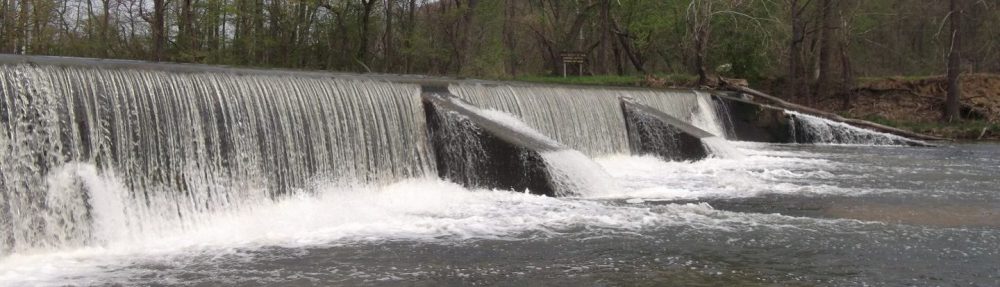
This the Wabash River public access site at the Five Crossings Park, at Covington in Indiana. These pictures taken on April, 7th, 2023.

Ever wonder why old barns are usually red in color? Red is (or, perhaps, was) a popular color for barns due not to its color shade but for its usefulness.
Many years ago, choices for paints, sealers and other building materials did not exist. Farmers had to be resourceful in finding or making a paint that would protect and seal the wood on their barns. Hundreds of years ago, many farmers would seal their barns with linseed oil, which is an orange-colored oil derived from the seeds of the flax plant. To this oil, they would add a variety of things, most often milk and lime, but also ferrous oxide, or rust. Rust was plentiful on farms and because it killed fungi and mosses that might grow on barns, and it was very effective as a sealant. It turned the mixture red in color.
When paint became more available, many people chose red paint for their barns in honor of tradition.


This once beautiful, Queen Anne style mansion, stood on this site, at the corner of Fourth and Alabama Streets, near downtown Lafayette, Indiana, since 1865.
On Memorial Day, May 26th, 2013, when these pictures were taken, it was awaiting demolition. It had served as a private residence, then in 1929, it was used as the Soller-Baker funeral home. It had stood empty since 1996. It was scheduled for renovation as apartments, or condo’s, but the project was abandoned when it became cost-prohibitive, in 2009.
Eventually, the City of Lafayette, bought it, with plans to demolish it and redevelop the site. There were many additions to the original mansion, whilst it was a funeral home. The brick additions were due to be dismantled first, starting June 4th, the main part of the mansion, about a week later.
Now, it has since been demolished and replaced with a new apartment building, called Regency Springs.
These are all my own photographs.

Wingate ME Church
Because of an old postcard I had seen from my county’s library website, showing the old Wingate M E Church, in Wingate, Indiana. I figured it would make a good “then and now” article. The old picture is from a postcard, from about 1910.
The description from the Library website:-
The Wingate Methodist
Episcopal Church (also known as the Wingate M. E. Church) is
pictured. Much of the church building is obscured by trees.
Digitized copies of this and other postcards were provided
by Jane Lyle, February 2011.
These pictures were both taken at the junction of Main and Main Cross streets, in downtown Wingate, Indiana. Taken from the south west corner, looking north east.

The M. E. Church, in Wingate, IN C.1910

The M. E. Church, in Wingate, IN, November 23rd 2012
The former Methodist Episcopal Church, now known as the New Hope Chapel, is located on Wingate, Indiana, at the junction of Main and Main Cross Streets.
If you compare the two pictures, you can see that there was a spire on the building, in 1910, as well as three entrance doors showing. There is only one entrance showing in the now picture, and the spire has been removed.
I located another similar postcard (below), also from the Crawfordsville Public Library website. It shows the Church and Parsonage, to the north of the church. That is now a house, seen on the left of the church, but is still there today.
The description from the Library website:-
Wingate (Ind.) M. E. Church and Parsonage. Sent to Della Fine, Wallace, Ind. [Dear Della. I that you had left the country. Why don’t you
come up. Come when you have a vacation. R. J.] Postmarked Nov 22, 19–.

 Tri Kappa ‘s
TOWN-WIDE RUMMAGE SALE WEEKEND
Covington, Indiana
Friday, June 8 – Saturday, June 9
Register your sale for only $10.00 (Single Family)
or $15 (Multi-family of 2 or more) to be included in a listing of all sales and advertised in the paper.
Deadline: May 25
Forms will be available on Covington Tri-Kappa Events +
Covington City Building
Covington County Market
Covington Public Library
The Fountain Trust Company
The annual Town wide rummage sales will be held in Williamsport, Indiana on Saturday May 12th, 2018, from 6AM to 3PM. This years event is hosted by the Williamsport Indiana Fire Department, 21 Front St / 5 N Monroe St, Williamsport, Indiana 47993.
The Williamsport town wide rummage sale is always held on the Saturday, the day before Mothers Day, for future reference.


For further details, please visit their Facebook page https://www.facebook.com/events/1649357808519059/

Mansfield, Indiana
The car show, an integral part of the annual mushroom festival, held in Mansfield, Parke county, Indiana, will be held on April 29th, 2018.
For more information about the Mushroom Festival CLICK THIS LINK http://www.mansfieldparke.com/mushroom-festival.html
Dash cam video showing the Rob Roy Covered bridge that was repaired and re-opened to traffic in the summer of 2017.
You can see more of my pictures at the following link Old Hillsboro Cemetery by cjp02 on Flickr
Old Hillsboro cemetery is located just south of US 136, behind the Post Office, near the center of the town of Hillsboro, in Fountain County, Indiana.
This one of four cemeteries in Cain Township, Fountain County, Indiana. According to Find A Grave there are approximately 420 burials in this old cemetery, the earliest from the early 1830’s. A lot of the headstones are weather worn, and have fallen over and broken, but some have been repaired and mounted on concrete plinths. There are 24 Civil War Veterans buried there.
The town of Hillsboro was laid out in the 1830s, and is the only settlement in Cain Township, having approximately 600 people, half the township population living there. It stands at the intersection of US 136 and Indiana State Road 341. Wikipedia
Cain Township was one of the first of the eleven townships to be established in the county on July 24, 1826. At that time, much of the land was forested, but 100 years later most of the land was used for agriculture. Wikipedia
Fountain County lies in the western part of the U.S. state of Indiana on the east side of the Wabash River. The county was officially established in 1826 and was the 53rd in Indiana. The county seat is Covington. According to the 2000 census, its population was 17,954; the 2010 population was 17,240. The county has eight incorporated towns with a total population of about 9,700, as well as many small unincorporated communities; it is also divided into eleven townships which provide local services. An interstate highway, two U.S. Routes and five Indiana state roads cross the county, as does a major railroad line. Wikipedia
The state of Indiana was established in 1816. The first non-indigenous settler in the area that became Fountain County is thought to have been a Mr. Forbes, who arrived here in early 1823 and was soon followed by others. Fountain County was officially created on December 30, 1825, the act taking effect on April 1, 1826; the boundaries of the county have not changed since that time. It was named for Major James Fontaine of Kentucky who was killed at Harmar’s Defeat (near modern Fort Wayne, Indiana) on October 22, 1790, during the Northwest Indian War. Wikipedia
You can see more of my pictures at the following link Robb Cemetery by cjp02 on Flickr
Robb cemetery is located beside Indiana State Road 28, between Williamsport and West Lebanon, in rural Warren County, Indiana.
Bob Quirk Oct 1, 2016
From the Journal Review newspaper and website.
http://www.journalreview.com/news/life/article_ddccf59e-8792-11e6-a46a-6b9ce8acfba0.html
The Wabash and Eric Canal was started in 1832 in Fort Wayne. It reached Fountain County in 1846 and when completed in 1853 was the longest artificial waterway in the country.
Transportation in the days before the canal was quite inadequate. The population of the state was growing and better transportation was badly needed to ship out the surplus farm produce and to bring in the much needed supplies for the pioneer families.
The canal being close to the Wabash river and running through swamps and low lands, malaria became a problem and later cholera made its appearance. The work was done by Irish immigrants who had been forced out of Ireland by the potato famine. These laborers died by the hundreds, and the death rate was so high that the digging of graves was almost as big a job as digging the canal. The situation was to grow so terrible that for every six feet of completed channel it had cost the life of one human being.
The laborers who died from the cholera in Fountain County were buried in a cemetery at Maysville, a thriving village of this period between Attica and Riverside, also on a plot of land in Shawnee Township on the Bodine farm, 2 1/2 miles north of the village of Fountain. Others were buried in the corner of Portland Arch Cemetery.
Even from the beginning it was necessary to distribute large doses of quinine, calomel and “Blue Mass” to the workers, with the whiskey-bearing jigger boss making the rounds three times a day, and six times on Sunday.
The Canal’s troubles did not end with the plagues, for when they were not burying their dead they were fighting each other, since the Irish workers on the project were about equally divided between men from North and South Ireland, Cork and Ulster. This meant a general skull cracking on religious grounds whenever two of them met.
It was a hard life for the laborers and living conditions were very bad. The dirt was moved by pick and shovel and wheelbarrows. It was the hardest kind of work, done under very difficult conditions.
There were many jobs to be done beside digging the canal. A supply of water had to be provided which usually required damming one of the tributary streams entering the Wabash River and raising its level so that water could be led from above the dam to the main canal by means of feeder canals. Aqueducts had to be built across some of the creeks. These were huge wooden troughs the width and depth of the canal and supported on posts or stone piers and with a plank tow path built on the side for horses. In some cases, streams were crossed by damming them at the opposite bank of the canal and raising the level of the creek to that of the canal thereby providing a water supply as well as a crossing.
Thus with the coming of the canal, local farmers had a market for the surplus farm goods and manufactured goods from the east were made available to them.
Soon there were passenger boats for people to travel on. I will tell about them in my next article.
Bob Quirk is a retired educator and historian. He contributes this column to the Journal Review.
http://www.journalreview.com/news/life/article_ddccf59e-8792-11e6-a46a-6b9ce8acfba0.html
Sagamore Parkway Eastbound Bridge demolition July 12, 2016.
Today, July 12th, 2016, one of the road bridges, over the Wabash River, was demolished, using explosives. This is the latest phase in the reconstruction project, of the bridge carrying the east bound carriageway of Sagamore Parkway, formerly US52, from West Lafayette to Lafayette, Indiana.
River Road, Old State Road 43, which is situated next the Wabash River, and passes under the bridge, has been closed from Monday July 11, 2016, for approximately one month.
Traffic from the east bound bridge has been diverted onto the other, west bound bridge, temporarily. The deck had previously been stripped off of the bridge framework, and the most easterly span was removed, before the framework was demolished, at approximately 9AM, on the 12th. Crews have been given 24 hours to remove the debris from the river.
The east bound bridge is situated south of the west bound bridge, and was constructed in 1936, and is therefore older than the west bound bridge. The two bridges are of completely different designs.
In 2006, the Vermillion County Community Foundation sponsored an art project involving 16 hand painted, 8 feet tall, fiberglass giraffes, on display at various locations in Vermillion County, Indiana.
To quote from an information booklet published at the time to publicize this event:-
Vermillion County, Indiana is home this summer to a unique art project – 16 eight foot tall giraffes decorate the landscape if Indiana’s longest county. Local sponsors and artists from this Western Indiana community have teamed up under the guidance of the Vermillion County Community Foundation to show their pride in being Indiana’s tallest county. The program is being so well received, the Lieutenant Governor’s Office of Tourism has even re-named State Highway 63 “Giraffe Parkway” in honor of the event.
The Foundation hopes visitors and residents alike will appreciate the giraffes which will be on display through October. Then, on November 5th they will each be auctioned off to the highest bidder to help the Foundation continue its work providing scholarships and grants to programs which showcase the county as a vibrant place to live.
The event is known as :- “Discover Surprises in Vermillion County – We’re Standing Tall”.
For further information and more pictures of these giraffes:- http://www.freewebs.com/colinsplace/giraffes/index.html
If you are researching Cemeteries and the people buried there, in Montgomery County, Indiana, a useful resource is the Crawfordsville Public Library website Cemetery Locator page:-
via Crawfordsville District Public Library: Cemetery Locator.
The Shawnee Bridge, is a through truss bridge, crossing the Wabash River, between Warren and Fountain Counties in Indiana, was built in 1905, by the Attica Bridge Co. of Attica, Indiana. It was rehabilitated in 1980. It is a two lane wide bridge, still open to vehicular traffic, but with a 10 feet height restriction. It has a total length of a little over 800 feet, made up of five approximately 160 feet long trusses.
It is located south of the Warren County seat of Williamsport, Indiana, and the small unincorporated town of Portland Arch, which is itself north of the Fountain County seat of Covington, Indiana.
Bridge Plaque Text:-
1905
Built by
The Attica Bridge Co.
Attica, Indiana.
R.L. Winks E.C. Livengood
Co. Auditor James C. Hall
W.H. Gemmer Ben.R. Gephart
Co. Engineer Co. Commrs.
Bridgehunter page http://bridgehunter.com/in/warren/8600029/
Williamsport is a town in Washington Township, Warren County, Indiana, United States. It is the county seat of Warren County and is the largest of the four incorporated towns in the county. http://en.wikipedia.org/wiki/Williamsport,_Indiana
Covington is a city in and the county seat of Fountain County, Indiana, United States. http://en.wikipedia.org/wiki/Covington,_Indiana
The Wabash River is a 503-mile-long (810 km) river in the Midwestern United States that flows southwest from northwest Ohio near Fort Recovery across northern Indiana to southern Illinois, where it forms the Illinois-Indiana border before draining into the Ohio River, of which it is the largest northern tributary. http://en.wikipedia.org/wiki/Wabash_River
http://www.waymarking.com/waymarks/WMM168_Shawnee_Bridge_between_Warren_and_Fountain_Counties_IN

Apparently this John Doe’s remains were found alongside nearby Interstate 65, in the mid 1980’s. His true identity was never discovered, but he is believed to be a victim of the serial killer, known in the media as the Highway Murderer. The emergency personnel, that answered the call to his discovery, raised the money for this headstone and burial. Although this small cemetery, in rural Jasper County, Indiana, near Rennselaer, is closed to new interments, the commissioners donated the plot, and allowed him to be buried here.
The Memorial text reads:-
JOHN DOE
25 TO 26 YEARS OLD
APPROXIMATE DATE
OF DEATH: MARCH 1982
INTERMENT APR. 22, 1986


I found this web page about Larry Eyler and his crimes, while researching this John Doe grave.
Larry Eyler, the Highway Murderer – Murderpedia
Chicago Tribune article from 2010
Save
This interesting bridge is of Warren Deck Truss construction. It was built in 1936, has a total span of 982 feet, and carries the east bound carriageways of US52, from West Lafayette to Lafayette, across the Wabash River and State Road 43, at Lafayette, in Indiana. http://bridgehunter.com/in/tippecanoe/19010/
As I type this, at the end of May 2016, work is about to begin to remove and replace this old bridge. The structure and superstructure are deemed to be structurally deficient, and also the construction is similar the I35W bridge in Minnesota that collapsed suddenly in August 2007. http://bridgehunter.com/mn/hennepin/mississippi-35w/
The pictures were taken from underneath the bridges, besides State Road 43, May 30th, 2016.
GPS: 40.451664, -86.895164

Marking a Piece of History in Veedersburg, IN
Indiana Racing Memorial Association Board Members Dick Mittman, Howdy Bell, Mark Eutsler, Brian Hasler and Bob Gates pose in front of the group’s 10th historic marker in Veedersburg. In 1909, Indianapolis Motor Speedway President Carl Fisher ordered 3.5 million bricks — 3.2 million of which were installed on the racing surface — from the Wabash Clay Company in Veedersburg at a cost of 13 cents each. The building in which he signed the contract is still standing about a half mile south of the historic marker. The company delivered the bricks in 63 days. IRMA Co-Founders Eutsler and Hasler are holding a panoramic photo of the company and its workers all of whom are identified. It was a gift to IRMA from the Town of Veedersburg. Following the unveiling a tour of the 22-acre site on which 26 kilns once stood was conducted by current owner Mark Carr.
Re Blogged from:-
http://www.journalreview.com/news/image_510ecd02-1632-11e6-b22f-db5e3ae6358c.html
Wabash and Erie Canal
Indiana was incorporated as a state in 1816, Fountain County, in 1825, and Attica was laid out and platted, also in 1825. The building of the Erie Canal in upstate New York proved so successful that the residents of Indiana saw the potential of such a canal here.
After much debate, on Feb. 23, 1832, formal ground breaking took place in Fort Wayne and in July 1832, actual construction took place and worked southwest; it reached Lafayette by 1842. The construction progressed slowly, reaching Covington in 1846 and by 1847, the canal reached Lodi in southern Fountain County. Now Fountain County was connected to Lake Erie by canal, and by 1847 traffic had begun to flow through the county via the canal. The canal had reached Terre Haute in 1849 and was completed to Evansville in 1853.
When completed the canal was 458 miles long and was the longest artificial waterway in this country and second only to the Grand Canal in China. The canal was 26 feet wide at the bottom and 40 feet at the top and contained 4 feet of water. The towpath on one side was 10 feet wide and 4 feet above water level. The locks were 60 feet long and 15 feet wide
At Fountain (Portland Arch) was the widest part of the canal between Terre Haute and Lafayette. It was the only place between the two towns that boats could pass. Warehouses were located at Mayville, Attica, Jamestown, Fountain, Covington, Sarah, Vicksburg and Silver Island. At these Fountain County locations merchandise was unloaded from the canal boats. For the next few years, these towns flourished from the traffic between Lake Erie and the Mouth of the Mississippi via the Ohio River.
The coming of the county’s first railroad, the Wabash and Western Railroad line, built through Attica, in 1858, heralded the end of the canal’s usefulness. By 1860, portions south of Terre Haute were closed and the process of decline continued northward. In the end, the canal was too expensive to maintain, and when less costly railroads were completed nearby, its use declined dramatically. Around 1875, the last canal boat passed through Covington, and In 1876, the entire canal in Indiana was sold at auction.
——————————————————————
An article by Bob Quirk, published in the Journal Review.
Erie Canal reaches Fountain County in 1846
The Wabash and Erie Canal reached northern Fountain county during the drought year of 1846. This drought brought about an event which came to be known as the “Attica and Covington War”.
The drought had caused the water level to be low in the canal and water from the Wabash River was also low. When the water from the Wabash River was finally directed to the canal it was found there was barely enough of it to flood the canal to Attica and none for the Covington section of the canal.
The Daniel Webster, a beautiful line boat, arrived in Attica after much difficulty and could go no further. The publisher of the Attica Journal printed an exaggerated report of the boats’ arrival in Attica.
When the lock at Attica was opened and only the barest trickle of water came through, Covington suspected the worst. They thought Attica was closing off the flow of water to keep Covington from using the canal.
Covington Senator Hannegan, who happened to be home from Washington, offered his influence of his position and his ability to debate, if a local committee would accompany him to Attica and get them to open the flood gate. The visit was made but with no success and they returned to Covington.
By daylight the next morning Senator Hannegan and 300 townsmen and farmers armed with clubs stormed up the river to Attica.
The news of their approach was quickly spread and a well armed wagon load of men dispatched. However, the Attican’s arrived too late and in a matter of minutes they were surrounded, captured, disarmed and held prisoner.
The invaders forced their way through Attica and succeeded in opening the floodgates, letting the precious water into the lower section.
Reinforced by additional villagers and crews of the helpless boats, the Attican’s attempted to reclose the flood gates. However, it was too late and in a matter of minutes the thirty canal boats lay topsy turvey, mired in the mud, dumping their precious cargo overboard.
Thus the Covington-Attica canal war was over with victory going to neither town. The fourteen mile section had absorbed all of the ensuing water, not leaving enough to float a raft, much less a canal boat.
However, this was not the end of the canal. It wasn’t long until the drought ended and there was sufficient water and it was reopened.
At first packet boats did not run on a schedule. They started their trips after a profitable number of passengers was assured to be on board. The distance a boat traveled from Toledo to Attica was 267 miles and it took about 2 and half days and cost $3.75. An advertisement in a Ft. Wayne newspaper read: fast sailing “Niagra has large stateroom with 3 meals a day.
As demand increased, boats were designed for freight and passenger separately. The passenger boats were even designed in two classes. One class was for passengers who wanted to arrive at their destination quickly and the other was designed more luxuriously and traveled 5 to 8 miles per hour. They charged one to two cents a mile or more for a ticket.
The internal arrangement had a small covered cabin for the crew. Next was a wash room and drawing room and then the women’s cabin. Next was a large room usually about 45 feet long which served many purposes.
During the day it was a place of general assembly and it was there that 3 meals a day were served. At night it was converted into a floating dormitory. There were about 42 bunks of small shelves of wood, about six feet long and one and half foot wide. The beds were covered with a thin clump of straw and a flat bag of blue canvas. A blanket and pillow completed the bedding supplies.
When it was time to retire a man would take off his hat, neck tie and collar, coat and vest and climb into bed. If he was unusually finicky, he would also take off his shoes and trousers before climbing into bed, but if he did those extras he was considered finicky.
In the morning before breakfast they lined up to wash in a tin basin filled with water from the canal. A comb and brush hung near the place where food was being prepared.
A show boat called, “The Dixie Boys Minstrel Show” operated along the canal. It had a seating capacity of 100.
P.T. Barnum’s Circus came to Attica in 1879. Tom Thumb, three elephants, a band of clowns gave a great show. The boats ran from March 1st until November 1st.
A tin horn announced the arrival and departure of the canal boat at each post.
The canal played an important part in the development of West Central Indiana, However, with the coming of the railroad, the canal era came to an end in the 1870’s.
http://www.journalreview.com/news/article_a31c3bda-1974-11e1-b039-001cc4c002e0.html
——————————————————————
This wedding was held on a canal boat on May 16, 1872, in Attica, Indiana, on the Erie Canal. http://www.in.gov/history/images/canalwedding.gif

——————————————————————
Further Reading:-
A couple of interesting articles, originally published in the Journal Review newspaper, written by Bob Quick are:-
http://www.journalreview.com/news/article_265516fc-01c9-11e1-adad-001cc4c002e0.html
http://www.journalreview.com/news/article_a31c3bda-1974-11e1-b039-001cc4c002e0.html
Some of the history of Attica is detailed on the city’s website http://attica-in.gov/visiting-attica/history-of-attica/
The Attica page on Wikipedia http://en.wikipedia.org/wiki/Attica,_Indiana

